Our next field trip.
2024-09-07 Burren (Mullach Mór) on Saturday 7th September 10:00–16:00 h
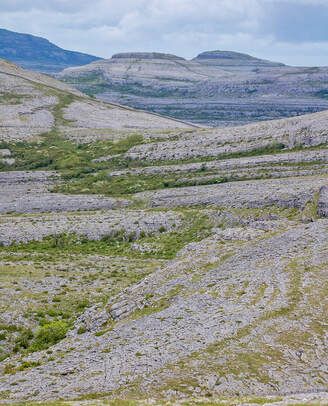
GGA field trip to south-eastern Burren (Mullach Mór) on Saturday 7th September (10 am to c. 4 pm).
Meet at Gortlecka crossroads at 10 am (52.9967981N, 9.0373889W; parking immediately to S of crossroads). Please note: car parking is limited so please take a lift if at all possible to reduce the number of cars & be kind to the environment
Dr Eamon Doyle (geologist, Burren & Cliffs of Moher Geopark) has kindly agreed to be our guide.
2024-09-07 Burren (Mullach Mór) on Saturday 7th September 10:00–16:00 h
GGA field trip to south-eastern Burren (Mullach Mór) on Saturday 7th September (10 am to c. 4 pm).
Meet at Gortlecka crossroads at 10 am (52.9967981N, 9.0373889W; parking immediately to S of crossroads). Please note: car parking is limited so please take a lift if at all possible to reduce the number of cars & be kind to the environment
Dr Eamon Doyle (geologist, Burren & Cliffs of Moher Geopark) has kindly agreed to be our guide.
Our next Lectures.
Ireland’s Fossil Heritage - Enhancing Public Fascination with Rocks and Fossils
Zoom lecture by: Dr. Jess Franklin
Senior Engagement Officer | Research Support Officer
School of Biological, Earth and Environmental Science (BEES), UCC
Date and time: Tuesday, 26th November at 19.00 h
For link email (nearer the date): [email protected]
Zoom lecture by: Dr. Jess Franklin
Senior Engagement Officer | Research Support Officer
School of Biological, Earth and Environmental Science (BEES), UCC
Date and time: Tuesday, 26th November at 19.00 h
For link email (nearer the date): [email protected]
Joint CGA/GGA lecture
Professor Inger Greve Alsos
UiT - The Arctic University of Norway (Tromsø University Museum)
Wednesday, 30th October 2024 at 19.00 h on Zoom.
Preliminary lecture title:
Ancient Sedimentary DNA: a powerful new tool for reconstructing past environments
Title of talk to be confirmed; further information to follow.
|
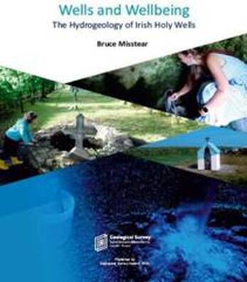
GGA April Zoom Lecture 9th April 2024 at 19:30 h
Wells and Well Being: The Hydrogeology of Irish Holy Wells by: Dr Bruce Misstear, Fellow Emeritus TCD Dr Bruce Misstear is a Fellow Emeritus of Trinity College Dublin where he has taught and researched groundwater topics for nearly 30 years. Prior to academia, Bruce was Divisional Director of consultant Mott MacDonald, working on groundwater projects in Africa, the Middle East and Asia as well as in the UK. He is the author of around 200 publications, including journal articles, books, book chapters and conference papers. His book Wells and Wellbeing: The Hydrogeology of Irish Holy Wells was published by Geological Survey Ireland in 2023 To receive a link email: [email protected] |
GGA fieldtrip to Joyce Country & Western Lakes Geopark 23rd March, 2024
Leader: Dr Benjamin Thebaudeau, geologist at
Joyce Country & Western Lakes Geopark
Tionscadal Geopháirc Dhúiche Sheoigheach & Lochanna an Iarthair / Joyce Country & Western Lakes Geopark stretches from the shores of L. Conn in the east to Killary Harbour in the west, and includes some of the most interesting geology and landscapes on the island of Ireland.
Dr Benjamin Thebaudeau, geologist at the Geopark, has kindly agreed to be our guide on Saturday 23rd March.
Programme (as of 14/02/2024) is as follows:
10:00: Departure (from Clonbur village; this is the start/end point)
10:15: Corr na Móna marble outcrop
11:10: Killary Harbour viewpoint
12:00: Lunch at Leenane village (Leenane Hotel)
13:00: Depart Leenane village. Stops at:
Deltaic and morainic glacial deposits and
Aill Dubh conglomerate outcrop and Maumtrasna viewpoint
13:40: Finny viewpoint and pillow basalt outcrop
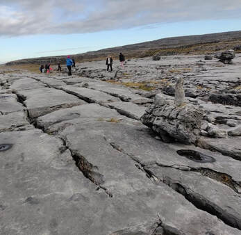
14:15: Karst nr Clonbur; this involves a short walk to an area with limestone pavement
16:00: End of fieldtrip at Clonbur
Please register by emailing us at:- [email protected]
Leader: Dr Benjamin Thebaudeau, geologist at
Joyce Country & Western Lakes Geopark
Tionscadal Geopháirc Dhúiche Sheoigheach & Lochanna an Iarthair / Joyce Country & Western Lakes Geopark stretches from the shores of L. Conn in the east to Killary Harbour in the west, and includes some of the most interesting geology and landscapes on the island of Ireland.
Dr Benjamin Thebaudeau, geologist at the Geopark, has kindly agreed to be our guide on Saturday 23rd March.
Programme (as of 14/02/2024) is as follows:
10:00: Departure (from Clonbur village; this is the start/end point)
10:15: Corr na Móna marble outcrop
11:10: Killary Harbour viewpoint
12:00: Lunch at Leenane village (Leenane Hotel)
13:00: Depart Leenane village. Stops at:
Deltaic and morainic glacial deposits and
Aill Dubh conglomerate outcrop and Maumtrasna viewpoint
13:40: Finny viewpoint and pillow basalt outcrop
14:15: Karst nr Clonbur; this involves a short walk to an area with limestone pavement
16:00: End of fieldtrip at Clonbur
Please register by emailing us at:- [email protected]
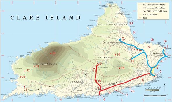
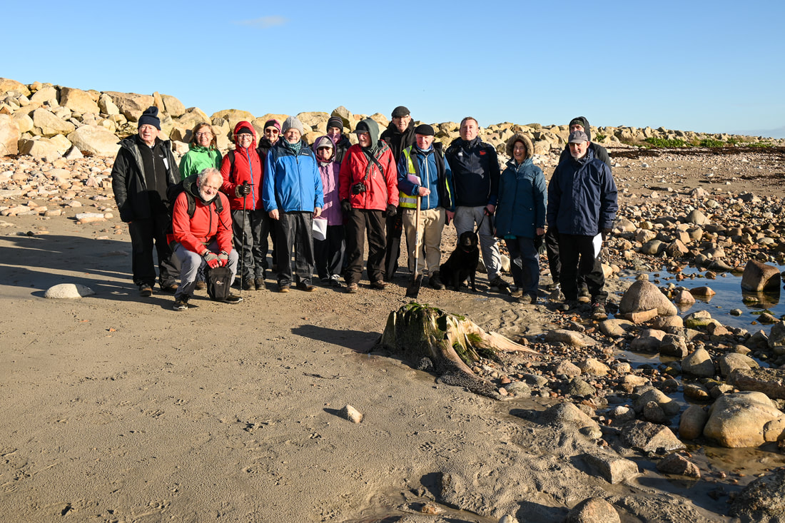
The next field trip will be a weekender to Clare Island on the 18 - 19 of May Led by Professor Pete Coxon (Geography, TCD)
Programme
Saturday 18th May
10:00 h: Fieldtrip commences at the Community Centre
Route 1.1. The eastern coastal sections of glacial deposits. This will allow the Quaternary geology of the island to be put in perspective and to see how the glacial landforms and deposits have been mapped. We then return to the Community Centre and join-up with participants who have travelled out on the morning ferry.
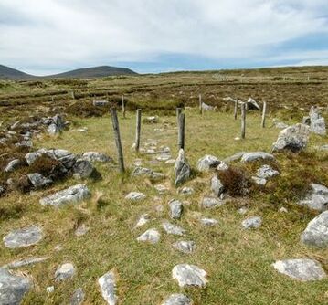
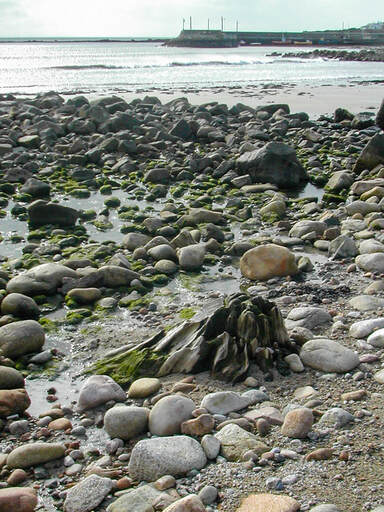
Route 1.2. This part of the fieldtrip takes us north-west to sites 15, 16, 17 and 19. At these sites we will see Holocene and Late-glacial peat deposits, a spectacularly sited court tomb, hummocky moraine, pine stumps and a contemporary woodland.
We can discuss the scale and timing of Quaternary events against the marvellous backdrop of a glacially altered landscape.
Participants should bring a packed lunch.
19:00 h: dinner at the Community Centre
Three course meal + tea & coffee. Cost: €30
Note: participants pay individually but important to indicate on registration if you wish GGA to make a booking for the evening meal on your behalf.
Sunday 19th May
9:30 h: Meet at the Community Centre and walk the southern coast route to view some of the ice-moulded bedrock of the island and drumlin sections. Along the route sites 6–12 will be discussed. Many features of glacial erosion can be seen in fine detail and we will be able to see first-hand how glaciers have altered the landscape.
We will have the opportunity to visit the Abbey and see its magnificent late Medieval wall paintings.
A walk up into the saddle between Knockmore and Knocknaveen will allow us to stand at the very edge of a glacial readvance during the collapse of the last ice sheet.
Participants should bring a packed lunch.
We plan to be back at the pier by 16:00 h, in good time for the evening ferries.
You will need to find accommodation if you wish to stay over night either on the island or on the mainland.
Again please register by email.
Programme
Saturday 18th May
10:00 h: Fieldtrip commences at the Community Centre
Route 1.1. The eastern coastal sections of glacial deposits. This will allow the Quaternary geology of the island to be put in perspective and to see how the glacial landforms and deposits have been mapped. We then return to the Community Centre and join-up with participants who have travelled out on the morning ferry.
Route 1.2. This part of the fieldtrip takes us north-west to sites 15, 16, 17 and 19. At these sites we will see Holocene and Late-glacial peat deposits, a spectacularly sited court tomb, hummocky moraine, pine stumps and a contemporary woodland.
We can discuss the scale and timing of Quaternary events against the marvellous backdrop of a glacially altered landscape.
Participants should bring a packed lunch.
19:00 h: dinner at the Community Centre
Three course meal + tea & coffee. Cost: €30
Note: participants pay individually but important to indicate on registration if you wish GGA to make a booking for the evening meal on your behalf.
Sunday 19th May
9:30 h: Meet at the Community Centre and walk the southern coast route to view some of the ice-moulded bedrock of the island and drumlin sections. Along the route sites 6–12 will be discussed. Many features of glacial erosion can be seen in fine detail and we will be able to see first-hand how glaciers have altered the landscape.
We will have the opportunity to visit the Abbey and see its magnificent late Medieval wall paintings.
A walk up into the saddle between Knockmore and Knocknaveen will allow us to stand at the very edge of a glacial readvance during the collapse of the last ice sheet.
Participants should bring a packed lunch.
We plan to be back at the pier by 16:00 h, in good time for the evening ferries.
You will need to find accommodation if you wish to stay over night either on the island or on the mainland.
Again please register by email.
Annagh Head, The Mullet, Co. Mayo. Photo: Paul Ryan
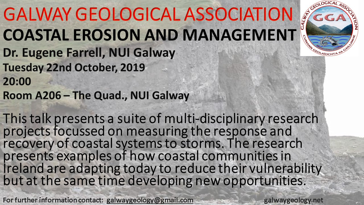
The megaclast deposit at Annagh Head, Co. Mayo is truly extraordinary. Locally derived boulders weighing up to 60 tonnes occur on the foreshore 5 m above and 200 m inshore of the cliff line. The extreme inundation event which formed this deposit has been attributed to either a tsunami (possibly older than 4 Ka) or modern storm waves. This talk argues that the geology of the deposit, local history and numerical modelling informed by recent oceanographic data all indicate that this is a cliff-top storm deposit. Such deposits give an insight into the destructive power of NE Atlantic storms.
Zoom lecture: Marine Boulders at Annagh Head: storm or tsunami deposits?
By: Professor Paul Ryan (Earth and Ocean Sciences)
Date and time: Tuesday 30th January, 19:30 h, 7:30 in old money.
New Fossil Find at the Cliffs of Moher
by
Dr. John Murray (Earth and Ocean Sciences, University of Galway)
Wed 13th December, 19:30 h
Link to join Zoom Meeting
https://us06web.zoom.us/j/85011758224?pwd=s13p3c3GTlzOKh32EYv0TvA9IacrYR.1
The link to the paper that John mentioned in his talk is:-
Murray, J., MacGabhann, B.A., Doyle, E., Mángano, M.G., Tyrrell, S., Harper, D.A.T. 2023.
An enigmatic large discoidal fossil from the Pennsylvanian of County Clare, Ireland. Palaeoworld, https://doi.org/10.1016/j.palwor.2023.01.008
or:-
https://www.sciencedirect.com/science/article/pii/S1871174X23000082
|
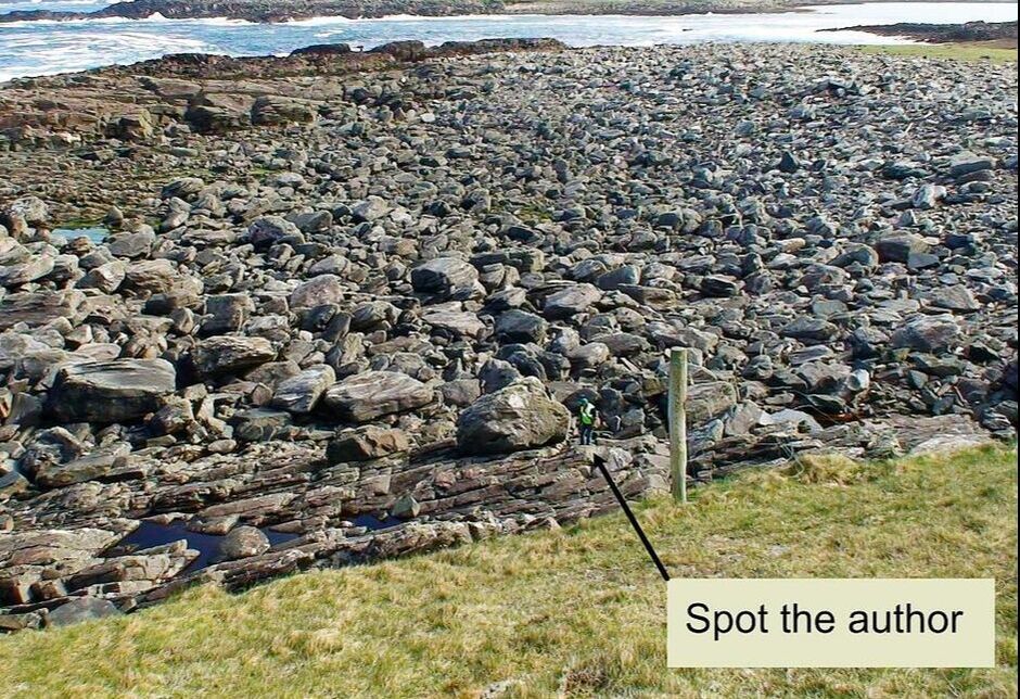
Regretfully, in view of the likely adverse weather forcast, we have decided to cancel the Mullach More trip until the Spring. |
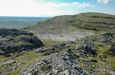
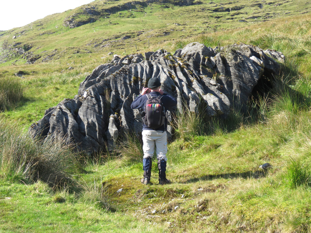
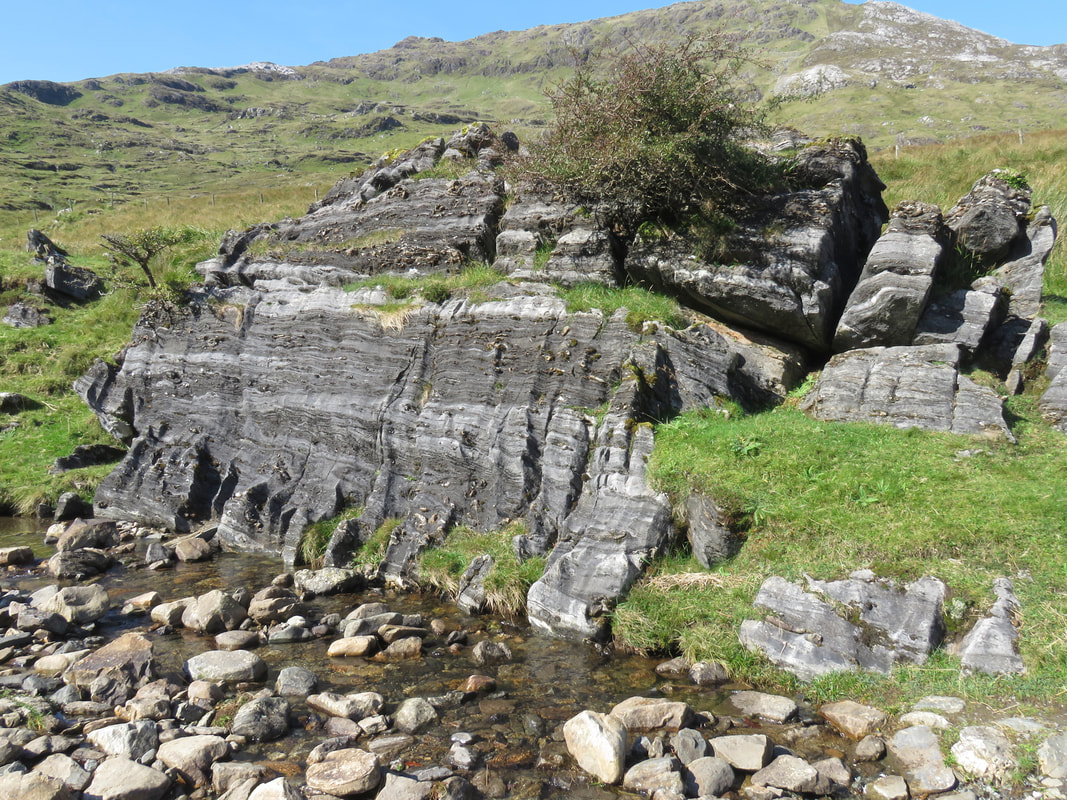
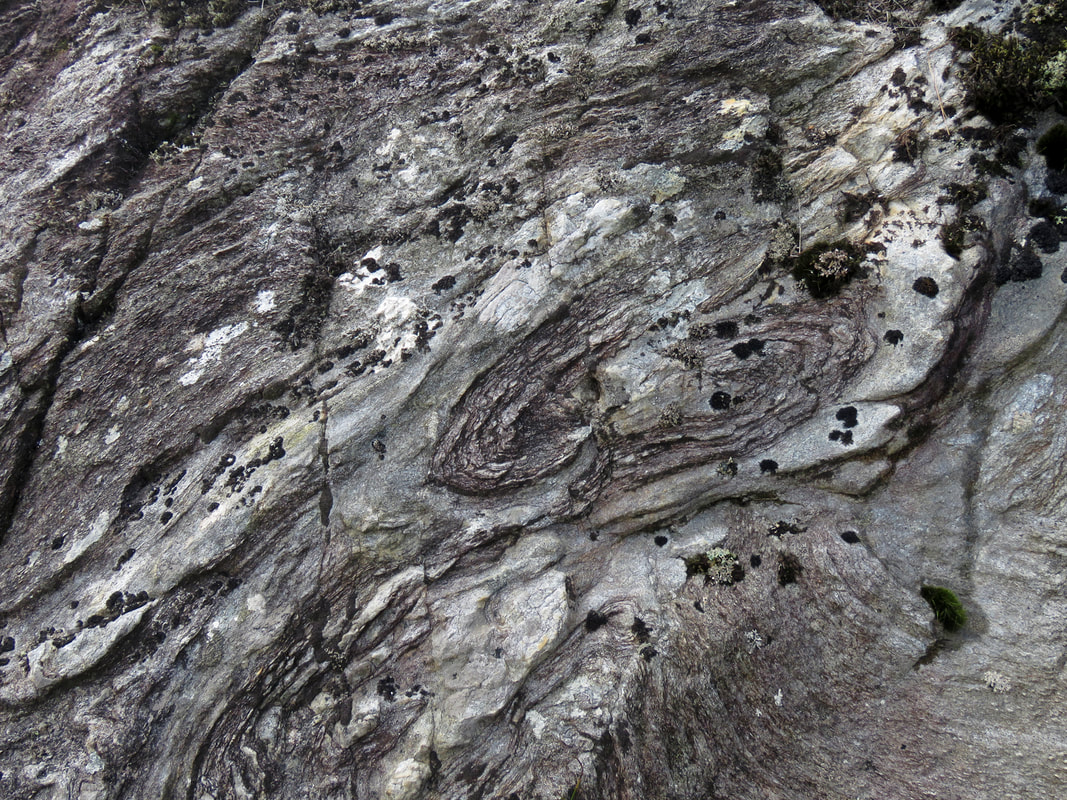
Uplands immediately N of Mullach Mór showing clints and grykes (2008-09-08; MO’C)
|
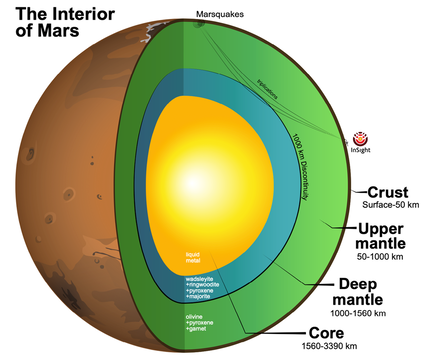
"Looking into Mars with InSight" Professor Vedran Lekic (University of Maryland)
Tuesday 7th November at 19:00
For four years, NASA’s lnSight mission to Mars measured the red planet's vital signs. lnSight’s very broad band seismometer has detected minute ground vibrations from marsquakes, winds, and meteorite impacts.
I present a selection of noteworthy seismic structural signals, including surface waves travelling across the northern highlands as well as body waves interacting with the core and the mantle transition zone, and converting across crustal interfaces.
The talk will highlight several key discoveries about the red planet’s seismic activity and interior structure.
Zoom Meeting ID: 865 8333 7005. Passcode: 3sWkGZ
|
10th October at 19:00 "Joyce Country and Western Lakes Geopark; It all starts with the rocks." Geoparks are regions with internationally significant geological heritage and where this heritage is valued and connected to landscape, ecosystem, archaeology and culture for the benefit of the communities living there. This talk by the Joyce Country and Western Lakes Geopark geologist, Dr Benjamin Thébaudeau, will tell the geological story of the region and how it relates to its amazing landscape and communities that visitors can see today. |
Please email for a Zoom link.
[email protected] |
|
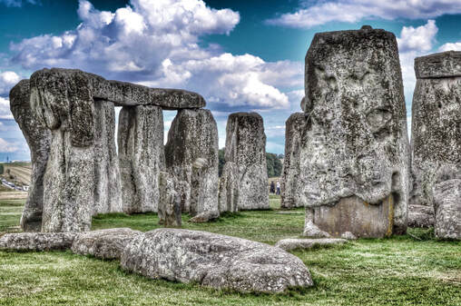
7pm on Tuesday 9th May. Dr. Jake Ciborowski of the University of Galway will present a talk entitled 'Sourcing the sarsens of Stonehenge, and the people who shaped them' |
The origins of the stones used to build Stonehenge and their transportation methods and routes have been the subject of debate among archaeologists and geologists for more than four centuries.
The smaller ‘bluestones’ (a catch-all term for a mixture of igneous rocks and sandstones, all clearly exotic to Stonehenge) have received most attention. These are now known to have come from various parts of west and south Wales.In comparison, the larger sarsens that make up the main architecture of Stonehenge have received little attention, and, until recently their source has remained unknown.
Answering this question is what we set out to do in our initial research. Building on this approach has lead to new discovers which help us understand how ancient civilisations built labour and resource networks.
Important news about our forthcoming trip to Clare Island.
Due to unforeseeable circumstances, the GGA has had to cancel this field trip.
The GGA apologies for any inconvenience caused. Refunds will be issued to those who have paid a registration fee.
It is the intention that a Clare Island trip be organised for autumn 2023 or during 2024.
The GGA apologies for any inconvenience caused. Refunds will be issued to those who have paid a registration fee.
It is the intention that a Clare Island trip be organised for autumn 2023 or during 2024.
Our next Zoom talk is scheduled to take place on Tuesday 25th April at 19:00.
Dr. Mark Cooper, Chief Geologist - Geological Survey of Northern Ireland,
will present a talk on 'Quantifying the Impacts of Faults and Dykes on Fluid Flow in Northern Ireland Permo-Triassic Reservoirs and Aquifers'. We hope that you will be able to join us. We will forward the link once it becomes available. Please see below, a short outline of Dr. Cooper's talk.
Building on a national-scale understanding of the distribution of faults and dykes 1,2,3, this work aims to assess their impact on Northern Ireland Permo-Triassic and other key reservoirs and aquifers. Structural and architectural data is being gathered to gauge how faults and dykes influence fluid flow. An immediate application of this work is that conceptual models can now include measured fault and dyke attributes, eg key orientations, average spacings, segments lengths, dyke thicknesses and gaps. Such information is helping to define compartment dimensions and connectivity which aids the development of realistic 3D and 4D flow models required for future geothermal, energy storage and groundwater applications.
The trip to Belderrig and Céide Fields, 15th April 2022.
Thirteen participants + Gretta Byrne (archaeologist) and Andy Lewis (geologist) turned up at Belderrig Pier at 11am. We spend an hour in the harbour area; first discussing the "shelly till" (mainly Andy Lewis and Gretta Byrne contributing). We then moved round to the east side of the harbour to look at the dolerite domes pushing up into the over-lying shales. f. We then proceeded to the Belderrig Farm where Gretta guided us. The excavations carried out by Professor Graeme Warren, Archaeology, UCD, at the eastern side of Belderrig Harbour, were also discussed. These relate mainly to the Mesolithic but also include substantial evidence for early Neolithic activity.
We had a quick lunch at Céide Fields Visitor Centre. After admiring the centrepiece, a huge pine trunk with its roots, taken from Belderrig, we went outside where Gretta elaborated on the main archaeological features of the site. The archaeological finds, especially from the Glenulra Enclosure, strongly support dating to the Neolithic period. The pollen evidence (pollen analyst: Karen Molloy) from nearby Glenulra Basin (6-m-long peat core) was discussed by Michael O’Connell who pointed out the strong Landnam (woodland clearance in the context of mainly pastoral farming) recorded by the fossil pollen. This has been securely dated to the Neolithic (3800–3150 cal. BC). It is likely that the large-scale, stone-wall system was laid in the first three centuries of this period, i.e. the early Neolithic, when the pollen record indicates particularly intensive farming activity locally.
By now, rain had started and so we retreated to the Visitor Centre but not before we had the opportunity to appreciate the spectacular coastal landscape of north Mayo with the sea-stack, Dún Briste at Downpatrick Head almost within touching distance, and the South Donegal uplands visible across Donegal Bay.
The field trip formally ended on return to the Centre. On behalf of the GGA and especially the participants, Prof. O'Connell (GGA chair) thanked Gretta and Andy for their contributions and presented them with books — Listen to the Land Speak by Manchán Magan, and Connemara & Aran by Walter Pfeiffer (photography and several poets) — as a token for their substantial contributions to the fieldtrip.
Participants then had some time to peruse the newly revamped Visitor Centre; if you haven’t seen it, then add it to your bucket list!
All in all, a very satisfactory outing. Lucky enough with the weather for most of the day although by 5 pm there was strong wind and rain which continued for most of the journey until we got home to Co. Galway.
````````````````````````````````````````````````
Bronze Aga Hut site, Belderrig.
Important information for intending participants
Registration: €10 (GGA members); €15 (non-members). Annual GGA membership subscription: €20; there is a reduced subscription (€10) for full-time students. Participants must be familiar with the GGA Health and Safety Statement. This will be circulated prior to the field trip. Safety is ultimately the responsibility of each participant. It is on this basis that you are accepted by the GGA as a participant in GGA events. For field trips, sturdy footwear (the terrain may be uneven), waterproof clothing and sun-screen (high factor) are essential. On the Céide Fields trip, drinks and food will be available at the Céide Fields Centre. You are strongly advised, however, to bring emergency drinks and food. Participants are requested to provide a mobile phone number. The leader’s mobile number (in this instance, Michael O'Connell) will be made available to all registered participants. If you require a lift please contact as soon as possible the Hon. Sec. GGA at Galwaygeology(at)gmail.com |
GGA visit to Céide Fields on Saturday, 15th April 2023
Itinerary details 8:30 Depart Galway, NUIG, an Aras. Travel by private transport. Car pooling is encouraged. Gretta Byrne, Director of the Céide Fields Visitor Centre, has indicated that participants are welcome to call to the Centre en route to Belderrig. 11:00 Stop 1. Belderrig Pier (54.3105478, -9.5518381). Parking available near the shore. Belderrig shore: dolerite cones (low tide is at 09:03 (2.2m) so the features of interest will be exposed) Glacial shelly drift (late last glaciation/Weichselian) Mesolithic archaeology site (much quartz; extensive deposits of later Mesolithic stone tools) Stop 2. Belderrig prehistoric Farm https://www.belderrigvalley.com GGA has been granted permission by the Caulfield family to explore this important site which has much evidence of Neolithic and Bronze Age activity and settlement. A guide book to the site will be available (€5; can be purchased on the day). 13:00 Depart Belderrig 13:30 Céide Fields Visitor Centre (54.30715, -9.45757). Entry fee: €4 pp. Parking is available at the Centre. Welcome by Gretta Byrne (archaeologist and Director of the Centre). Lunch in the cafeteria Viewing the new exhibition 14:30 Exploring the stonewall field systems and other features of this spectacular site. This will be led by Gretta Byrne with inputs from Andy Lewis (geologist) and Michael O’Connell (palaeoecologist). The visit will end at about 16:30 h. Downpatrick Head (54.322896, -9.345525) and Dún Briste sea-stack may be visited on the way home. This is optional. |
|
Dr. Tiernan Henry, University of Galway, will lead a joint EOS*/GGA field trip to Tynagh Mines and the Slieve Aughty mountains on Saturday 11th March.
Prior to visiting the mine we will stop at the Slieve Aughty Mountains to gain a sense of the geological setting of Tynagh Mines and the geological setting of "Ireland" in the Silurian to the Carboniferous |
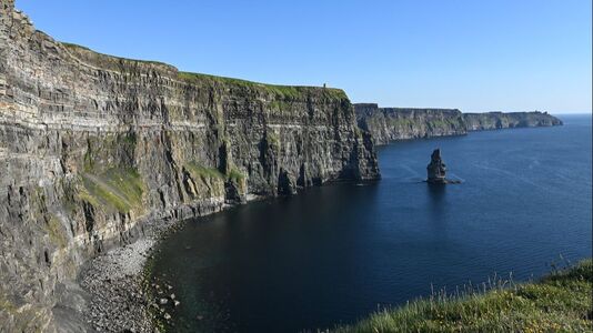
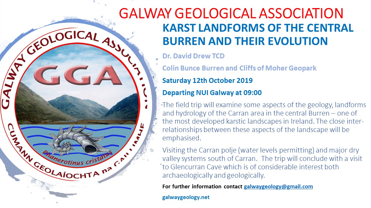
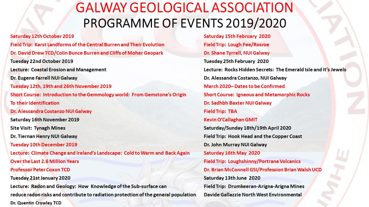
February 18th (Saturday): Burren, Co. Clare. 'Structural controls on the development of karst in the Burren'
Leader: Professor John Walsh (UCD; School of Earth Sciences)
This is an all-day, starting at Ballyvaughan (9 am), on to Black Head (R477) and along the coast road via Poulsallagh, ending at Doolin Cave for 3 pm tour. Prior registration is essential.
The meeting point is in Ballyvaughan, in parking area at waterfront on R477 (53.1187842,-9.1530656).
There is a charge for Doolin Cave (€17.50; €15 senior; see https://doolincave.ie/). GGA will arrange for a ticket to be reserved for you if you indicated this when registering (email [email protected]).
The cave visit is optional but highly recommended
March 11th (Saturday): Tynagh Mines, east Galway
Leader: Tiernan Henry (UoG: Earth and Ocean Sciences)
This trip is run in conjunction with Earth and Ocean Sciences, UoG
April 15th (Saturday): North Mayo with focus on Céide Fields and Belderrig (archaeology and geology)
Leader: Professor Michael O'Connell (UoG), with contributions from Gretta Byrne (director) and staff of Visitor Centre, Céide Fields
This is an all-day field trip
May (weekend trip on 13th and 14th, Saturday and Sunday): Clare Island
Leader: Professor Pete Coxon (TCD).
This weekend trip involves at least one overnight (Saturday 13th). The trip begins about 11 am at the Community Centre near the pier (after arrival of morning ferries). It will end at/before 4 pm on the Sunday (in time to catch an evening ferry).
Ferries (two ferry companies) run from Roonagh Pier to Clare Island. Social welfare travel pass is accepted.
A communal meal will be arranged for participants on the Saturday evening.
Note: accommodation is in short supply on Clare Island. If you intend participating, it is important to arrange accommodation as soon as possible. For information on accommodation and ferries see:
https://clareisland.info/
June (date to be announced)
Gorumna Island, SW Connemara with focus on the southern contact of the Galway granite
Leader: Dr Sadhbh Baxter (UoG; Earth and Ocean Sciences)
A day trip
~~~~~~~~~~~~~~~~~~~~~~~~~~~~~~~~~~~~~~~~~~~~~~~~~~~~~~~~~~~~~~~~~~~~~~~~~~~~~~~~~~~~~
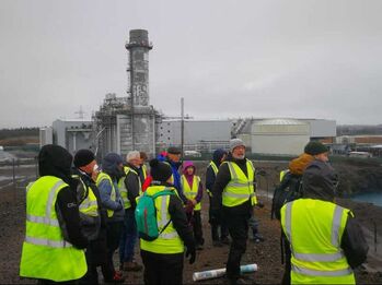 Photo - Kevin Rogers. Photo - Kevin Rogers.
Meeting Point: Ballyvaughan - parking area at the waterfront on the R477 Co-ordinates 53.1187842,-9.1530656 (on front of the Burren Atlantic Hotel and the Tea and Garden Rooms).
Departure Time: 09:00 The field trip will conclude with a tour of Doolin Cave at 15:00. Participants must be familiar with the GGA Health and Safety Statement. This will be circulated to participants prior to the field trip. Safety is ultimately the responsibility of each participant. It is on this basis that you are accepted by the GGA as a participant. It is recommended that you bring waterproof clothing and boots with good ankle support plus a packed lunch including drinks. There is a risk of slips and falls on the Burren terrain. There are 125 steps down into Doolin Cave. Participants may be requested to car share. There will be a charge of €10 euro for Geological Association members and €15 for non-members. This may be paid in advance by electronic bank transfer to the GGA account . There will be a charge of €17.50 for the tour of Doolin Cave with a reduced charge of €15.00 for seniors. This charge will be paid by each individual on arrival at the cave. Please note that the tour of the cave is optional but highly recommended. |
The Tynah Mine field trip March 2023 by Paula Gleeson.
There were 3 sections to the day...2 in the Slieve Aughties, where we trudged through snow and up to a point where both Tiernan and Sadhbh talked about the conglomerate we were standing on...bout an hour in heavy rain! We then went about half way down and into the left to a disused quarry (we have been there before) where the conglomerate could be seen, sitting on top of solid limestone blocks, under which lay an equally thick layer of sandstone. There for approx 45mins, where he dealt with the importance of sandstone in the transportation and ability to carry fluids. I and others always thought that it was layers of shale that held gases, as in fracking. However, the shale is the cap, but under the shale are layers of sandstone and it's the roundedness and equality of size that facilitates fluids-and gases. All this in rainfall, some periods heavier than others. We then went onto Tynagh, where we walked up to a point, where we could see a large lake with another one beside it, but looked manmade. Tynagh was the subject of Tiernan's PHd, so he talked at length (yes, in the rain! ) on the fact that a fault line runs from the Slieve Aughties across to and through the Tynagh area. Water passed through the sandstone to this area depositing a toxic combination of minerals, which formed a boat shaped formation of a dense pocket of copper, iron, zinc, lead sulfides under hydro thermal activity. On a fault line, there's a hanging wall and a slip wall. All the minerals are contained in the hanging wall. As the water runs alongside the hanging wall, it absorbs all these minerals, some of which are quite toxic. It was discovered and mined from 1961 to 1982-3. Ireland still has the richest deposits of zinc in the world. A lot of the toxins were sulphates, and when the fluids passed on through the surrounding limestone, it had a neutralising effect on them. The main lake was the original mining area, and the man-made one beside is the tailings deposit...the left overs after mining. LOADS of info given to look up. I'm beginning to recover now, but the weather was rough going, and needless to say, the young students got soaked! |
Saturday 18th February. Professor John Walsh, UCD, will lead a field trip to the Burren. This is a follow-up to his talk to the GGA.
If you intend to join us please respond by email at your earliest convenience as we need to inform Doolin Cave of the number of participants for the tour.
[email protected]
|
GGA is pleased to announce a lecture by Dr Alessandra Constanzo @EOS_Galway on Tue 7th February (tomorrow) at 19.00 h on: Natural vs. Laboratory Grown Diamonds: The “shining” truth among all that sparkles!
Fáilte roimh cách! All welcome! For link email: [email protected] 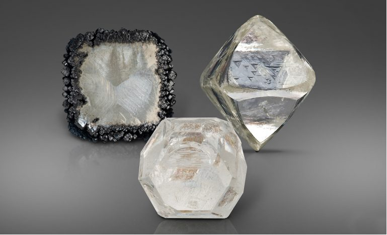
|
Dr. Alessandra Costanzo is a senior technical officer at UoG where she is responsible for the Diploma in Scientific studies in Gemmology. She has a GEM-A Diploma in Gemmology and a GEM-A Diamond Diploma and obtained the Certificate of Appraisal Theory from the Institute of Registered Valuers. She also completed several specialised courses such as a pearl specialistic course, a colour stones grading course and currently completing the jewellery education and training JET 1 by the National association of jewellers UK. She worked as a lecturer at the The School of Jewellery, Birmingham City University with which she is now collaborating. She is currently an Online Distance Learning Tutor for The Gemmological Association of Great Britain. |
|
Our next Lecture will be given by Emeritus Professor Paul Ryan of the University of Galway. He will be talking on The Anomalous Location of Dalradian Connemara relative to Ordovician Murrisk. Tuesday 6th Dec. 7pm. Zoom link will be advertised nearer the date. |
|
The island of Ireland was 'assembled' during the early Palaeozoic by the closure of the Iapetus Ocean and the collision of the continents of Laurentia and Avalonia. In NW Ireland and Scotland early stages of this closure was associated with the Ordovician Grampian Orogeny, attributed to the collision of oceanic arcs to the 'south' with the Laurentian margin to the 'north'. The suture of this collision is often located along the Fair Head - Clew Bay line (FCL). In western Ireland the FCL marks the boundary between the Precambrian of NW Ireland (basement and Dalradian cover both attributed to Laurentia) with the early Palaeozoic of Murrisk which contains the volcanic complexes of South Mayo (attributed to the Iapetus Ocean). The Dalradian of Connemara is of Laurentian affinity and was subjected to the Grampian Orogeny. However, Connemara lies to the south, not to the north, of the FCL. This 'anomalous' position has been attributed to strike-slip dismemberment of the Grampian tract. This talk will review the evidence for the nature of the Grampian Orogeny in western Ireland within the context of the Caledonian - Appalachian mountain belt and argue that the position of Connemara is more a product of the pre-Grampian geometry of the Laurentian margin than post-Grampian faulting.
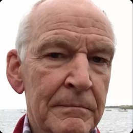
Congratulations to Prof. Svanté Pääbo on being awarded this years' Nobel Prize for Medicine. He is pictured here (left), with Dr. John Murray, on his second visit to NUIG in 2008 to give his lecture "From Fossils to the Genome" to mark the 150th anniversary of Prof. William Kings naming of the human antecedent Homo neandertalensis. www.bbc.com/news/health-63116304
*******************************************************************************************
GGA field trip to Co. Offaly: aspects of the geology of Slieve Bloom Mountains and nearby lowland eskers.
Leader: Dr John Feehan (Birr, Co. Offaly and UCD)
(J Feehan is author of The Geology of Laois and Offaly (2013) and several other substantial books and articles of local, regional and national interest)
Date: Saturday, 15 October, 2022.
Travel is by car. Please indicate if you can offer a lift or need a lift.
Participants are requested to register beforehand by emailing [email protected].
Registration fee: €10 (GGA and cognate fieldclub members); €15 non-members. The fee is payable prior to the field trip (electronic transfer to GGA account) or on the day.
Travel is by car. Please indicate if you can offer a lift or need a lift. Please bring a packed lunch and suitable attire.
Participants are requested to register beforehand by emailing [email protected].
Registration fee: €10 (GGA and cognate fieldclub members); €15 non-members. The fee is payable prior to the field trip (electronic transfer to GGA account) or on the day. GGA annual membership: individual €20; family: €30; student €15
Slieve Bloom has become one of the most popular midland destinations for walkers and bikers in recent years. Extensive blanket bog and glacial deposits blanket the solid geology almost everywhere except along upland streams. The late Silurian and Old Red Sandstone rocks that are well exposed on these upland streams have a fascinating story to tell. On the GGA trip, we will visit one of these stream sections and later visit one of the most intact and complex esker systems in Ireland at Knockbarron, north of the Slieve Bloom Mountains.
Weekend field trip to Sligo
On Saturday 24th and Sunday 25th September, Professor Ian Sanders led a field trip to the north-east Ox Mountains and Carboniferous Coastal Localities. This was a follow-up to the Zoom talk he presented to GGA last season.
Saturday, 24 September 2022 Assembly point is: St Bridget's Church (Catholic) on N59; to west of Ballysadare.
Co-ordinates: 54.20817, -8.53379 Time: 10:40 h.
The first official stop is on a small road a short distance to the west.
Sunday, 25 September 2022 Assembly point is: Mullaghmore; N of Classiebawn Castle.
The first stop is within walking distance. Co-ordinates: 54.46272, -8.46593 Time: 9:30 (for 9:45).
The first stops are within walking distance.
Please note that car pooling is required because of restricted parking facilities at some stops. If you are willing to provide a lift for other participants please indicate beforehand or on the day. Also, let us know if you require a lift. There is a charge of €20 for members of GGA and cognate associations including Sligo Field Club; the charge for non-members is €30; if participating for one day only a half fee applies. Payment may be made in advance by electronic bank transfer to the GGA account (details below) or on the day (Hon. Treasurer/Committee members will be present). It is important to email GGA in advance (email: [email protected]) and register.
Please observe precautions/advice re. Covid-19 restrictions. Please note: while GGA is concerned for the safety of participants and takes all reasonable precautions to ensure that Health and Safety Guidelines are observed at all times, participants safety on field trips is ultimately the responsibility of each participant. It is recommended that participants bring waterproof clothing and boots with good ankle support. Participants should bring their own packed lunch on both days. An evening meal has been arranged for 19:45 h on Saturday in the Glasshouse Hotel, Swan Point, Abbeyquarter North, F91 NCA4, Sligo town. A three-course meal in the Kitchen Restaurant costs €39.00 per person. Please indicate ASAP if you wish to join us ([email protected]). The booking is under the name GGA/Michael O’Connell.
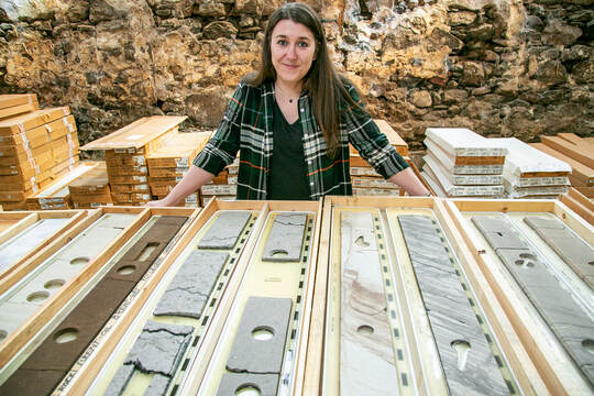
Title: North Sea Core and its Mission to Save Unwanted Subsurface Samples
Presenter: Dr. Kirstie Wright, Director, North Sea Core CIC
Please contact [email protected] for a Zoom link to the talk.
North Sea Core and its mission to save unwanted subsurface samples
North Sea Core was established in 2018 after the release of large quantities of core material by oil and gas companies, which was marked for disposed in landfill. Run by a small team and often with the help of volunteers, we work to make geoscience accessible through practical core samples and open access digital data. Our aim is to provide geological material for education, research and outreach, as well as individuals and commercial organisations. The majority of the material we hold comes from the UK North Sea, ranging in age from the Carboniferous to the Paleocene. So far, >9296 m of core from 186 wells has been redistributed to more than 100 locations in 20 countries. This talk will present how North Sea Core works, why we believe core material is worth saving and how we are using it to help educate the next generation of geoscientists.
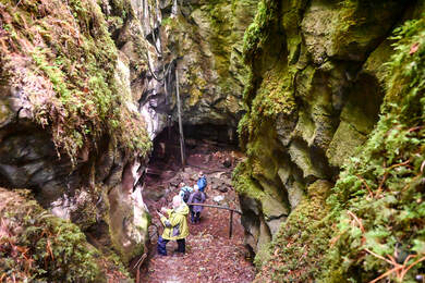
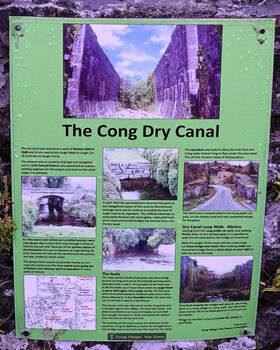
Galway Geological Association field trip to Cong (on the Galway/Mayo border),
on Saturday 11 June 2022 was led by Kevin O’Callaghan of Atlantic Technological University (ATU), Castlebar campus.
The main focus was on the ‘dry canal’, i.e. the substantial remains (dry canal bed, locks, an aqueduct (now carrying a road!), bridges, overflow channels) from the ambitious, but ultimately failed, attempt in the late 1840s to connect Lough Mask with Lough Corrib by canal at the village of Cong. Impressive karstic features in the area, including dolines and caves in the woodlands to the south-west of the village, were also explored.
Photos by Prof. Michael O'Connell
|
|
|
Professor Sally Gibson of the University of Cambridge will give a talk on 'Connecting deep Earth and surface systems: constraints from the Galapagos'.
The Galápagos is one of the world’s most volcanically active regions, with eruptions of basalt occurring every ~5 years (the last was in Jan 2022), and the research of myself and colleagues has shown that the locations of the volcanic islands and diversity of magmas erupted in Galápagos is a manifestation of complex physical and chemical processes in the underlying mantle and crust. I will outline how some of our new research -- that combines geochemical data for Galápagos volcanoes with high-resolution seismic databases is enhancing our understanding of the relationship between deep Earth processes and volcanic, oceanographic and biological systems, and explore how Galápagos acts as a unique natural laboratory in which to explore these connections. |
Our next lecture will be on Tuesday 17th May at 7pm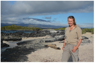
|
Our first formal field trip in over two years
will take place on Saturday 23rd April. It will be lead by Dr. Tiernan Henry, Head of Earth and Ocean Sciences, NUIG and Dr. Eamon Doyle, Geologist, Burren and Cliffs of Moher Geopark.
"Following the ups and downs, ins and outs of a Burren river"
There will be five stops:
Stop 1: Slieve Elva
Stop 2: Killeany Church
Stop 3: Lisdoonvarna Castle (south)
Stop 4: St Brendan's Well
Stop 5: Spa Wells Lisdoonvarna
Due to parking issues at some of the stops, we have organised a minibus. No other vehicles can be allowed so limited places. Departure will be from the Quad at NUIG at 09:00. There will be a second pick-up point at Ballyvaughan church carpark (53.113739401529536, -9.150690322875409). Departure from here will be at 10:00. The field trip should conclude by early afternoon.
In terms of access etc, Stop 1 will require some walking (c.1km) up a forest access road. Stop 4 definitely requires stout footwear! It's not long, but the track in to St Brendan's Well is usually muddy and a bit slippy. All other stops are gentle and easy walks.
We'll cover geology, groundwater and the mix of the two!
To reserve your seat please respond to this email and indicate if you will join us at NUIG or Ballyvaughan. The cost is €25.00 per person. Only a few seats left!!.
|
Our next lecture will be on Tuesday, 15 Feb 2022 at 7pm. Professor John Walsh @johnjfwalsh(#UCD) speaks on: The structural geology of the Burren and the Aran Islands: implications for the terrain in South Galway and North Clare. For a Zoom link please email [email protected] |
Our last lecture, in association with
IGA and CGA:
Seafloor Mapping:
From Inshore Ireland to the Abyss
By Aileen Bohan
(Geological Survey Ireland/ GEBCO)
When: Thursday 27th January 2022, 7pm
Where: Online via Zoom; please register by email to [email protected]
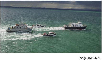
We will begin by looking at INFOMAR, the successor to the Irish National Seabed Survey, and the importance of seabed mapping for an island nation, before investigating a variety of seafloor features and shipwrecks from around the Irish coast. We’ll then look at the seafloor from a global perspective, focusing on the work of GEBCO (General Bathymetric Chart of the Oceans) and their collaborative project with the Nippon Foundation to produce, by 2030, the first full bathymetry map of the ocean seafloor (Seabed2030). We’ll finish with a look at a major data contributor to Seabed2030, the Five Deeps Expedition. This took place in 2019 and involved crewed descents via submarine to the deepest points of the world’s five oceans.
IGA and CGA:
Seafloor Mapping:
From Inshore Ireland to the Abyss
By Aileen Bohan
(Geological Survey Ireland/ GEBCO)
When: Thursday 27th January 2022, 7pm
Where: Online via Zoom; please register by email to [email protected]
We will begin by looking at INFOMAR, the successor to the Irish National Seabed Survey, and the importance of seabed mapping for an island nation, before investigating a variety of seafloor features and shipwrecks from around the Irish coast. We’ll then look at the seafloor from a global perspective, focusing on the work of GEBCO (General Bathymetric Chart of the Oceans) and their collaborative project with the Nippon Foundation to produce, by 2030, the first full bathymetry map of the ocean seafloor (Seabed2030). We’ll finish with a look at a major data contributor to Seabed2030, the Five Deeps Expedition. This took place in 2019 and involved crewed descents via submarine to the deepest points of the world’s five oceans.
GGA members at Barna/Silverstrand, Galway on M. O'Connel's field trip, Dec. 4th 2021.
|
The next GGA Fieldtrip This will be held on Sat. 4 Dec. Meet at Silverstrand car park 10.30. Grid ref. 53.2514758N, 9.1274322W Route: we will walk from Silverstrand to Barna and back. Duration: c. 2 h. We’ll explore: drumlins, coastal erosion, sea-level change, intertidal peats and bog deal. Boots & warm rainproofs essential. See https://www.galwaygeology.net/; All welcome but please confirm by emailing: [email protected] It is really important to observe the recommended Covid precautions regarding social distancing and masks, etc. See you there. |
What is Ireland’s Fossil Heritage?
Ireland’s Fossil Heritage is a science engagement project funded by Science Foundation Ireland (SFI). We are based at the School of Biological, Earth and Environmental Sciences at University College Cork (UCC). The project aims to increase awareness of, and interest in, Irish fossils by offering a diverse range of free resources to the public, including school workshops, a travelling exhibit, science and art collaborations and lots of interactive web content for all ages and backgrounds.
Why should we care about Irish fossils?
Ireland’s natural landscape is made up of diverse and unique rocks which contain clues about the ancient Earth. We can connect to this mysterious past by discovering and exploring the rocks beneath our feet. Hidden within some of these rocks are the remains of plants and animals that lived in Ireland millions of years ago. These fossils can teach us about exciting prehistoric worlds.
Website https://www.ucc.ie/en/fossil-heritage/
Twitter @Irish Fossils https://twitter.com/IrishFossils
Instagram irish fossils https://www.instagram.com/irishfossils/
Facebook Ireland’s Fossil Heritage https://www.facebook.com/IrelandsFossilHeritage
Metamorphic rocks in the northeastern Ox Mountains inlier, Professor Ian Sanders of TCD Time: Nov 9, 2021 07:00 PM
 Background photo - ©Robin Pettigrew Background photo - ©Robin Pettigrew
This talk will be preceded at 6.15 by our AGM. All members are encouraged to attend this to have your say in the running of the association. |
Unusual metamorphic rocks, unique in these islands and rare in the world, are preserved in the northeastern limb of the Ox Mountains inlier, which is a narrow strip of old rock trending diagonally across the country to the SE of Sligo town and bordered on both sides by younger Carboniferous limestone. The rocks are derived mainly from basaltic and sedimentary parents, and they reached temperatures approaching 900°C and depths of between 30 and 40 km, probably about 470 million years ago during the early Ordovician period. In the talk I will describe a suite of these rocks which I collected from an area south of Lough Gill. I will discuss the kinds of rock they were originally, before becoming metamorphosed. I will ask how the enormous depths and temperatures they are believed to have experienced were estimated and will show evidence for how the pressure and temperature conditions changed through time. I will ask how the age of the metamorphism has been inferred, and I will conclude by speculating briefly on how the story of these rocks relates to our general understanding of how plate-tectonic processes affected rocks in the west and northwest of Ireland during the early Ordovician. The link to the lecture emailing us at - [email protected] |
|
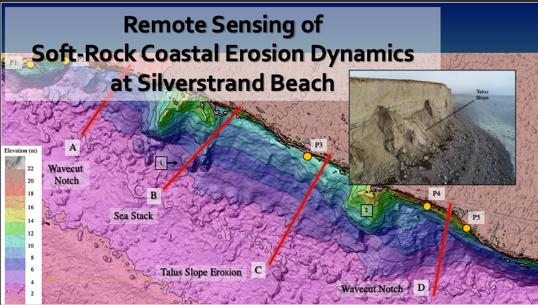
GGA Talk: Remote Sensing of Soft-Rock Coastal Erosion Dynamics, Silverstrand Beach
This talk by Rachel Smith (2019 MSc in Coastal and Marine in Environments, NUI Galway) will focus on the use of remote sensing methods to characterize the spatial-temporal morphology of soft-rock cliff erosion at the glacial depositional feature, Derryloney Drumlin, at Silverstrand Beach near Galway. Rachel will outline the geological setting and characteristics of the drumlin that make it an ideal target for ongoing erosion monitoring and discuss the success of applied remote sensing at the site. The project was able to capture geomorphological data suitable for estimating eroded sediment volumes, cliff-top retreat rates, and the formation and destruction of geomorphic features on the beach. Photo credit: Rachel Smith (2021) |
|
|
Dr Sadhbh Baxter of NUI Galway is giving a talk to the Belfast Geologists Society on Monday, 17th May at 7:30pm. The title is 'Western Wonders: a virtual geology trip in the west of Ireland' The login is:-Meeting ID: 864 1223 2517 Passcode: 0RSTR4 |
Our next Zoom lecture will take place at 7pm on Tuesday, 18th May. Dr. Tiernan Henry, Lecturer in Hydrology and Head of Earth and Ocean Sciences, NUI, Galway will give a talk entitled 'The Gowlaun: The Burren's Secret River.'
Look on maps of County Clare, and you'll see the Aille River marked, rising east of Lisdoonvarna, running through the Spa Well and on to the sea at Doolin. The only problem is when you go to the Spa Wells there are two rivers meeting - the Aille, which is by far the smaller of the two in terms of water volume, and the Gowlaun. But follow the Gowlaun on a map and it's only marked as a short stream. It rises at St Brendan's Well, where water can be seen gushing up from a fissure in the limestone. Follow this, and it takes you north and east to the valley between Slieve Elva and Cullaun, where the water rises at Killeany, draining from the caves that run along the flanks of the hills.
Data collected over recent months suggests that rainfall on the hills has an instant impact on the water levels in the caves, but there's a lag of four to five hours before the water starts rising at Killeany. Enough rain, and a turlough forms (in a matter of a couple of hours) below the rising. This water drains to the south, rising briefly then back underground before rising three to four hours later at St Brendan's Well.
And when the rain stops, the springs still run, because the upland peat continues to drain water. The system is built on two broad lithologies: the pure bedded limestone and the younger shales and sandstones. The system is enhanced by the peat on the uplands, retaining the water for weeks and slowly releasing it, making the springs perennial. We're not suggesting a name change, but the Aille is really the Gowlaun...
Click on the link below to join the meeting.
Time: May 18, 2021 at 7pm
Join Zoom Meeting, Meeting ID: 829 3910 5105
https://us02web.zoom.us/j/82939105105
======================================
And once again we have been invited to join the CGA for their next lecture.
It will be by Dr. Richard Unitt, University College Cork on Wed. May 19th at 8pm.
It is entitled “Larkin's Quarry, Connemara - The Discovery of a World-Class Mineral Locality in Ireland”
A very recent discovery has put Larkin’s Quarry on the map!
All are welcome. To register for the Zoom meeting please email [email protected]
The Cork Geology Association will host a lecture on Wednesday 28th April at 8pm.
Dr. Peadar McArdle, former Director of the Geological Survey, Ireland, will give a talk on
“Thomas Weaver (1773-1855): Ireland's first economic geologist?”
Abstract: Before he was thirty, Thomas Weaver was a successful engineer and geologist who was managing Avoca's main copper mine as well as the nearby Woodenbridge gold workings. Born in Gloucester, he trained in Freiberg's mining academy, where the celebrated Abraham Werner was professor of geology. He would have been easily accepted as a member of Wicklow's Protestant Ascendancy. In the unsettled political climate of the 1790s he was a senior officer in the Cronebane Yeomanry and helped to suppress the 1798 rebellion. He carried out extensive geological mapping. His 1819 map and publication covered large areas of east and southeast Ireland, an enormous endeavour. It was much praised for its insights, including on the origin of Avoca's copper ore. In the 1820s he worked on many prospects around Ireland, including the Ross Island mine at Killarney. Around this time he mapped a large part of the south of Ireland, but his subsequent publication met with considerable criticism. He lived through an extraordinary revolution in geological ideas, during which he often took a dissenting role. His many contributions will be discussed.
All are welcome. Please register by emailing [email protected]
The next Tuesday lecture is on the 20th April at 8pm. and is entitled:-
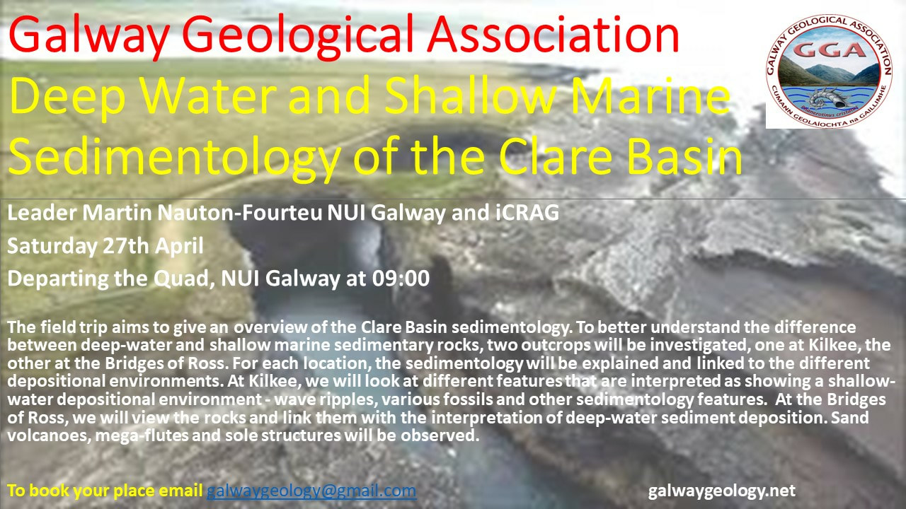
"The Geology of the Clare Basin – constraining sediment sources, basin fill and palaeogeography."
Dr Martin Nauton-Fourteu - Earth and Ocean Sciences, NUI Galway
"The Geology of the Clare Basin – constraining sediment sources, basin fill and palaeogeography."
Dr Martin Nauton-Fourteu - Earth and Ocean Sciences, NUI Galway
"The Clare Basin of western Ireland consists of remarkable mid-Carboniferous sedimentation from deep-water to shallow marine settings. Outcrops along the coast of counties Clare and Kerry attract scientists from around the world to study these sedimentary deposits. Additionally, basin fill history has been hotly debated over the past decades with contrasting models. This talk will be composed of a review of the sedimentology of the Clare Basin, combined with recently acquired cutting-edge sedimentary provenance data, to shed light on the Clare Basin fill and Carboniferous paleogeography in Ireland."
It will be hosted on Zoom in association with the Irish and the Cork Geological Associations and the link is:-
https://us02web.zoom.us/j/84680290833 Meeting ID: 846 8029 0833
It will be hosted on Zoom in association with the Irish and the Cork Geological Associations and the link is:-
https://us02web.zoom.us/j/84680290833 Meeting ID: 846 8029 0833
Link: https://us02web.zoom.us/j/81015147840
It would be appreciated if you’d email: [email protected] and let Hon. Sec. know that you are participating. |
Galway Geological Association (GGA) is please to announce a Zoom talk this evening at 7 p.m. (Tuesday, 23rd March.
Speaker: Dr. Bettie Higgs, Cork Geological Association Title of talk: Understanding the Earth: the work of Marie Tharp In 1912 Alfred Wegener first published his ideas on continental drift. He refined those ideas over the next 20 years, but continued to face resistance and ridicule from much of the scientific community. Why was this? When we look back on his ideas now they look remarkably far-sighted. This talk will tell the story of scientific egos and misplaced loyalties, and of how Wegener’s hypothesis eventually came to be accepted. It will explain the detailed and painstaking work carried out by another geoscientist, Marie Tharp, which when revealed to the scientific world was a turning point in the story and key to the development of the theory we now know as Plate Tectonics. |
Also today (Tuesday, 23rd March; at 2 pm): Eoin Moran, Director of Met Éireann gives a Z talk titled
Predicting the weather and future climate scenarios
Zoom link is https://nuigalway-ie.zoom.us/j/97109013365
Further details at: https://twitter.com/SIAM_NUIGalway/status/1372922866438656002
Predicting the weather and future climate scenarios
Zoom link is https://nuigalway-ie.zoom.us/j/97109013365
Further details at: https://twitter.com/SIAM_NUIGalway/status/1372922866438656002
This will be followed on Tuesday 20th of April 19:00 by a talk presented by Martin Nauton-Fouteu. Martin has recently submitted his PhD thesis on the Geology of the
Clare Basin and led a GGA field trip to The Bridges of Ross, Co. Clare in 2019. Again this will be on Zoom.
Clare Basin and led a GGA field trip to The Bridges of Ross, Co. Clare in 2019. Again this will be on Zoom.
|
Our first event of the new year will be held on 20th January at 19:00 via Zoom.
Three Irish geological associations (CGA, IGA and GGA) have joined together to host a Zoom lecture by Dr. Chris Standish, from the University of Southampton, titled “An Irish El Dorado? Searching for the Source of Chalcolithic and Early Bronze Age Gold” To register email- [email protected] before 20th January. |
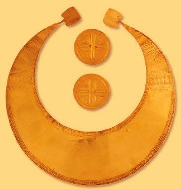
The first use of gold in Britain and Ireland occurred during the Chalcolithic and Bronze ages; it was used to produce neck ornaments, bracelets, cups and cape fasteners. The source location(s) of this gold must be understood if we are to understand why this material was first considered valuable and so understand the patterns of its procurement, trade and exchange. There has been a long-held belief, but no proof, that this source was located in Ireland. Geochemical provenance studies offer a means by which the source(s) of metals can be traced. Dr. Standish will discuss both past and current attempts to source Britain and Ireland’s earliest gold. Probable source areas will be proposed, and the implications of these on the perceived value of gold in early metalworking communities will be explored.
|
Galway Geological Association Lecture
|
Michael O’Connell
Palaeoenvironmental Research Unit, NUI Galway Upland landscapes with particular reference to western Ireland: charting the course of change since the glaciers retreated. Date: Tuesday, 8th December 2020 Time: 20:00 Via Zoom. For link email: [email protected] (free to GGA members; €10 annual subscription) |
Irish uplands are invariably treeless, usually covered by bog and heath, and support extensive grazing, often but not exclusively, by sheep. In this lecture, the history of how these important Irish landscapes evolved and the factors involved in bringing about the many changes that have shaped them — including geology, natural processes, climate and climate change, and human impact — will be discussed. The focus will be on the Galway/Mayo region but uplands elsewhere, including the Iveragh peninsula, Co. Kerry, will be considered.
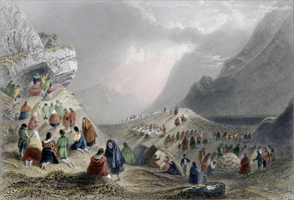
Hand-coloured, engraved print depicting a pattern (pilgrimage) in the early nineteenth century at Mám Éan (view from the southern approach; Griffiths and Bartlett, 1835)
Hand-coloured, engraved print depicting a pattern (pilgrimage) in the early nineteenth century at Mám Éan (view from the southern approach; Griffiths and Bartlett, 1835)
Dr Matthew Parkes
Ní bheidh a leithéid arís ann. www.gsi.ie/en-ie/events-and-news/news/Pages. /Death-of-a-colleague---Matthew-Parkes.aspx |
The extended Geological Survey Ireland family was shocked and saddened to learn of the sudden death of one of our own, Matthew Parkes, over the weekend. Dr Matthew Parkes worked for many years in Geological Survey Ireland before moving to the National Museum of Ireland. He retained Scientific Visitor status at Geological Survey Ireland and maintained his connection with us through his work on the County Geological Audits, the Irish Fossil collection and database, and through his annual involvement in the BT Young Scientist exhibition. He encouraged education and outreach collaboration between Geological Survey Ireland and the National Museum of Ireland and their current project, an exhibition on Irish Geoscience, co-curated by Matthew, to mark the 175th anniversary of the establishment of Geological Survey Ireland will open at the National Museum of Ireland - Collins Barracks, Dublin, after current COVID-19 restrictions are lifted. Our sincere sympathy is with his family in Ireland and Britain, his geoscience and museum colleagues around the world and everyone saddened by his sudden death. |
Field trip to Mám Éan, Maumturk Mountain Range, Connemara; Saturday, 26th September 2020
Leader: Professor Michael O’Connell
GGA was fortunate, from the point of view of weather (couldn’t be better) and Covid-19 restrictions (level 3; re-introduction of level 5 had not yet appeared even on the horizon), that this one-day field trip happened at all! Bright and early on the Saturday morning at the end of September, eleven GGA members made their way to Maam Valley and the assembly point, namely the car park sought of Corr. Here the Western Way leads to Mám Éan pass. Nobody felt under any pressure as the way up (only 150 m ascent) was at a slow pace with many stops for observations and discussions, and enjoying magnificent views across the lowlands and the uplands of north Connemara and Joyce Country beyond. The group tackled topics as diverse as the Dalradian, Ordovician and Quaternary periods, including the Lateglacial climatic oscillation, the Holocene and the Anthropocene, and indeed more besides.
At the pass, schist outcrops overlooking the corrie lake provided the perfect spot for lunch and further open-air discussions in scenic surrounds. Having paid respects to St Patrick and thanking him for making it this far into Connemara, the group proceeded to the Recess side of the pass. From here, most of Connemara was on view, with the Twelve Bens to the west, and to the south Lissoughter, Cashel Hill and Errisbeg and the Atlantic coastline beyond. The opportunity was also taken to discuss the evidence for local glaciation and all that entailed for local landscape development.
For photographs, etc. see Twitter thread at https://twitter.com/MOConnell07/status/1310626231289872385
Also see the maiden tweet in the brand new GGA Twitter account @GalwayGga https://twitter.com/GalwayGga/status/1316486093177597954
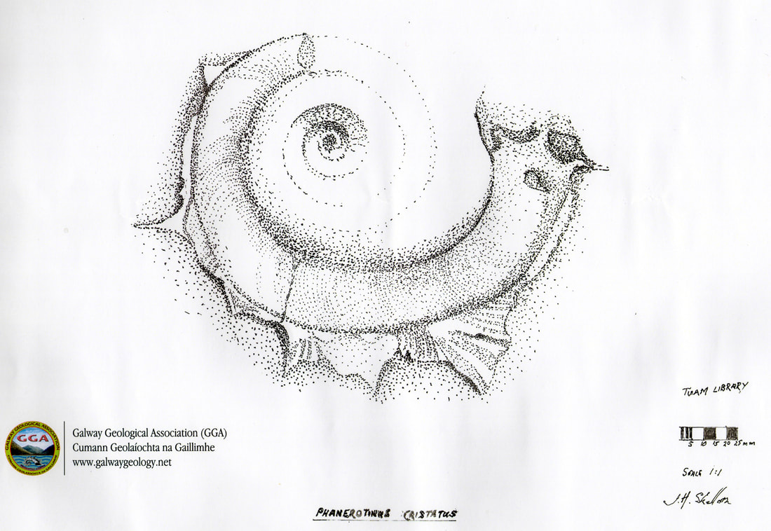
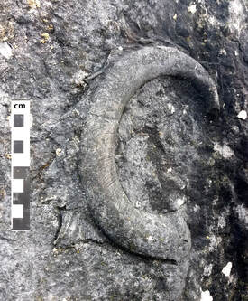
Drawing of specimen of Phanerotinus cristatus discovered in 2017 in the town of Tuam, Co. Galway by GGA member Brendan Arrigan. The drawing is by Jonathan Skellorn, former Chairperson of the GGA. This fossil of exceptional quality is one of about fifteen such that have been discovered to date worldwide. They all relate to the Carboniferous Period, ca. 340 million years ago. www.gsi.ie/en-ie/events-and-news/events/Pages/Unveiling_of_fossil_Phanerotinus_Cristatus.aspx
|
|
GGA member Brendan Arrigan made the discovery of his life when he chanced upon a splendid specimen of our emblem, Phanerotinus cristatus, embedded in a wall near Tuam. He found both the fossil and the counterplate, a rare occurence. After consultations with NUI Galway geologists and the National Museum it has been recovered for safe keeping and study.
Worldwide, only 15 of these unusually large fossils have ever been discovered to date, and they are only to be found in a band of limestone stretching between Ireland and Britain. Phanerotinus cristatus was a gigantic snail with spiny flanges around the outside. It lived on the sea floor at a time when Ireland was situated close to the equator and covered by a warm tropical sea.
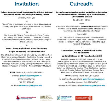
An unveiling will take place at Tuam Library on Monday 30th September at 2pm by Cllr. Jimmy McClearn, Cathaoirleach of the county of Galway and Seán Canny TD, Minister of State Community Development, Natural Resources & Digital Development. The ceremony will be open to the public and will include a welcome from Koen Verbruggen, Director of Geological Survey Ireland, short talks by Brendan Arrigan about finding and rescuing the fossil, and by Matthew Parkes, geological curator in the Natural History Museum, putting the find into the context of a Geological Heritage Audit of County Galway. The fossil will be placed at Galway County Council Office, High Street, Tuam on public display in Tuam for a period of time and also at a branch of the National Museum of Ireland in Dublin.
Worldwide, only 15 of these unusually large fossils have ever been discovered to date, and they are only to be found in a band of limestone stretching between Ireland and Britain. Phanerotinus cristatus was a gigantic snail with spiny flanges around the outside. It lived on the sea floor at a time when Ireland was situated close to the equator and covered by a warm tropical sea.
An unveiling will take place at Tuam Library on Monday 30th September at 2pm by Cllr. Jimmy McClearn, Cathaoirleach of the county of Galway and Seán Canny TD, Minister of State Community Development, Natural Resources & Digital Development. The ceremony will be open to the public and will include a welcome from Koen Verbruggen, Director of Geological Survey Ireland, short talks by Brendan Arrigan about finding and rescuing the fossil, and by Matthew Parkes, geological curator in the Natural History Museum, putting the find into the context of a Geological Heritage Audit of County Galway. The fossil will be placed at Galway County Council Office, High Street, Tuam on public display in Tuam for a period of time and also at a branch of the National Museum of Ireland in Dublin.
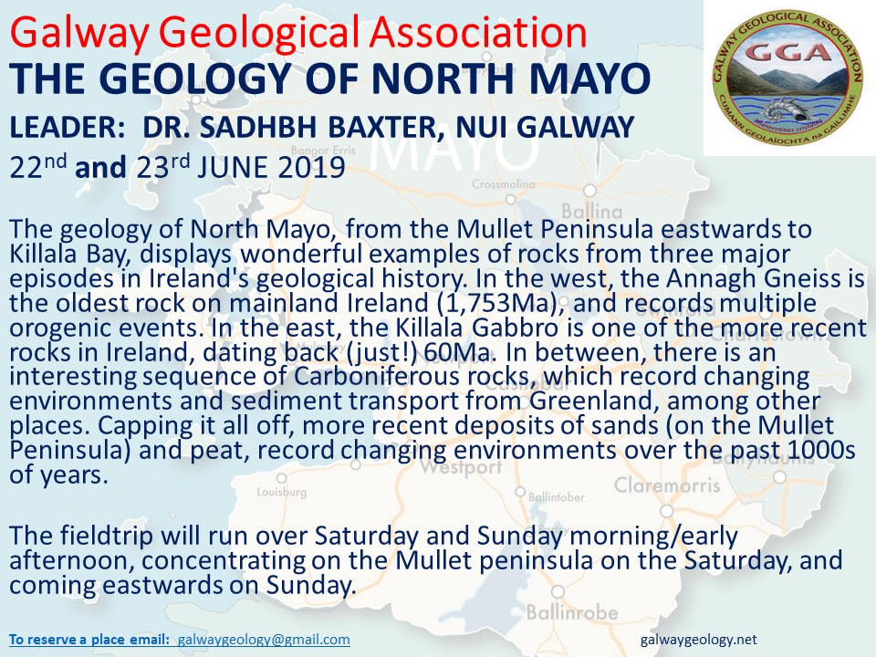
The GGA field trip to South County Clare, 27th April, 2019
Photos courtesy of Prof. Michael O'Connell.
There is a paper from the journal Sedimentology describing the features to be seen at the Ross site that we visited. Thanks to Martin for this. If you would like to get a PDF of it, send an email request to [email protected]. (use the 'contact us' form)
There is also a page on the web site of the Society for Sedimentary Geology (SEPM) devoted to the Gull Island Formation with many captioned photos including some of the things we were unable to see due to the tide and weather conditions.
http://www.sepmstrata.org/page.aspx?&pageid=472&6
Unfortunately, this event is fully booked.
~~~~~~~~~~~~~~~~~~~~~~~~~~~~~~~~~~~~~~~~~~~~~~~~~~~~~~~~~~~~~~~~~~~~~~~~~~~~~~~~
Our email address is - [email protected]
https://www.facebook.com/Galway-Geological-Association-1346374415460987
https://www.facebook.com/Galway-Geological-Association-1346374415460987
